
Inquiry: Atlas
Atlas keeps disappearing.

I’ve been looking for Atlas, Illinois, my entire life.
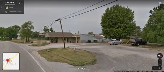
For years, my daily commute involved turning east at the four-way stoplight in the center of this unincorporated town in the western part of Pike County, about 100 miles from St. Louis. After Atlas came a series of rural hamlets without zip codes that held nothing but a rock shop, a trading post that sold beer and arrowheads, one of the last drive-in theaters in America, and finally my employer: a fruit stand with three shopping carts in New Hartford, right off of Highway 54.
Despite its name, Atlas was always tough to locate. Back when road maps were still handed out free in gas stations, Atlas was always my navigational landmark. I grew up in Pleasant Hill, seven miles south along the Great River Road; as a child, I learned how to find my hometown on a map by tracing a finger along the Mississippi River, the edge of the state, looking for Atlas.
Now, of course, you can just type in “Atlas, Illinois” and Google Maps will take you there. If, however, in a fit of anachronistic self-flagellation, you type only “Atlas,” you’ll get a list of GIS companies nearest your location, suggesting more maps for you to consider.
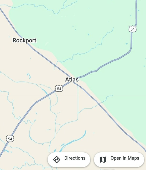
But even if its existence on the world’s largest digital atlas goes only half-heartedly acknowledged, Atlas’ position at the intersection of State Highway 96 and U.S. Highway 54 has ensured the town a consistent imagistic cataloguing. Since 2007, all of Atlas has been thoroughly captured and documented by Google Maps’ all-seeing cartographic eye. And though I left the area in 2012, I have been watching minute but transformative alterations to Atlas through Google’s portal ever since.
I justify these digital sojourns by telling myself that it gives me a visual companion to the stories I hear from my parents who still live nearby—the new bridge to Missouri has finally opened, and the Atlas Cafe, under new ownership, has great fried fish. But the truth that Google Maps confirms, through more than a decade of images, is that most things eventually seem to leave.
Moving through the years across the slider on Google Maps will show you this: The trading post has closed, the rock shop burned down, and the drive-in theater up the road weeded over, waiting for a digital projector. Even some of the trees have left from the nursery, which holds up one quarter of Atlas’ four-way intersection. The hot rods up in “Hot Rod Heaven Too” will also one day roll away, housed in a building that was once an antique mall. The oldest building in the county—now a private residence—still stands here in Atlas, though, regal and severely out-of-place in a town that never grew up around it.
There are other Atlases in the United States, in Wisconsin, West Virginia, and Texas. Somehow, they all seem to look just like my Atlas: rural, unincorporated communities with a smattering of houses, and sometimes a church and a cemetery, as if to fully incorporate and grow an atlas has always been impossible.
The images that capture the town’s decline come with ever-important digital watermarks, which imply that Google itself is claiming the imagistic history of Atlas. The company has preserved a part of my own history, too, caught as I have been by its lens the summer before I left Atlas for good, loading trucks and delivering produce up the road at Ackles Farm Market. That’s my Ford Ranger in the picture, the one with the decals off my high school football helmet.
I admit this is at the root of my fascination with this atlas of Atlas: I was there once, and here is the proof.
And yet, because Atlas doesn’t possess its own zip code, Google continuously insists on saying that my virtual visits to Atlas are to the town with the nearest post office. By refusing to name the place, the most comprehensive mapping system ever invented denies me fully what I know to be true: that I am categorically in Atlas when I find it on a map. Google Maps does this across the world, of course, but it is especially poignant in a town of this name. If Google Maps displays that nothing in Atlas stays, perhaps it means that it is a real town that has grown fake, captured and preserved best by the technology that has replaced its namesake.
On the other hand, perhaps Atlas’ physical fade from the ledgers of cartographic relevance is fitting. Atlas has always set the precedent for navigability, as it should: one intersection, two highways, straight lines all forming a nearly perfect “X” here near the navel of the United States. Like a train porter, it wills everyone away in all four cardinal directions. West out of Atlas holds the promise of the Mississippi River, north out of Atlas will get you to an interstate, south takes you to my hometown, and east takes you up out of what used to be the river’s basin and into endless flat plains. Like an atlas you can hold, it presents itself as mere possibility, all the way up to the margins.
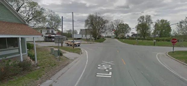
Sitting with my mouse hovering over this intersection on Google Maps, I realize that the one thing that seems to hold Atlas in place is the blinking red stoplight, which perpetually watches over the town much the same way that the Google Maps car does. The light gives people a reason to pause, if only briefly, before speeding off on their way to somewhere else.
Atlas has always been a passing-through place, and never the destination. Yet with every blink of the stop light, it still asserts itself as part of everyone’s journey through it. In that sense, maybe it has done its namesake some kind of justice, in a way that Google Maps’ still images can’t ever fully capture.
Right now, that stoplight in Atlas is blinking.
There it was.
There it is, again.
Originally published as “On Google Maps, a Town Called Atlas Keeps Disappearing” in CityLab.
The Five and Dime is a member of the Iowa Writers Collaborative. Each week, the Collaborative features new work from writers like Art Cullen, Mary Swander, Peter Hedges, and dozens of others writing across Iowa publishing on Substack.
You can find out more here:

Thanks for being a part of this.
Part adventure, romance, investigative reporting and even a little twilight zone to boot! Very entertaining. Thanks for the riddling ride to Atlas!
i often look up small, nowhere towns on wikipedia. it's a thrill to try to glimpse into the lives of people there. i might, if further intrigued, then look them up in google maps and street view. i spent several hours one day steet viewing my stepfather's family's dairy farm in rural michigan, and the roads, the approaches, to it. it was both familiar--as a kid i'd sometimes spend thanksgiving or christmas day there (it seemed always cold and gray, though not unpleasant)--but also strange and unknown. anyway, really enjoyed your piece. thanks.